MAP OF VALENCIA

Casaroro Falls in Valencia
Considered as one of the treasures of the municipality of Valencia in Oriental Negros, Casaroro Falls has attracted foreign and domestic tourists of all ages despite the steep trails that one has to go through to reach the falls.
The Casaroro Falls got its name from the phrase “Casa ni Roro” or “House of Roro”. It is located some 9.4 kilometers west of Dumaguete City and is considered as the most photographed waterfalls in the entire Negros province.
The falls is lodged deep into the rock crevices of the rugged mountains of the town of Valencia. Before, the only way to reach the falls is to climb uphill and down a steep gorge. In recent years, however, a 350-step concrete stairs was constructed and is now the only access point to the falls. While going to the falls up the concrete staircase, visitors experience the dense tropical foliage of Valencia and may even see rare species of birds.
With a height of 100 feet, the Casaroro Falls’ water plunges into a deep cold basin before it flows down to a stream. Unlike other waterfalls, the Casaroro is narrow, making it unique. The volume of water that drops from the falls is still heavy though despite the narrow cascade and causes a roar as it touches the pool. There are natural boulders around the basin, which are perfect for resting after the trek to the falls.
Getting There to Casaroro Falls in Valencia
The town of Valencia is less than an hour’s drive from downtown Dumaguete City. One can ride a pedicab, or jeepney ride to central Valencia. From the unloading point, one has to take a 30-minute ride to an area alongside the mountain where the trek begins. Those traveling in groups can also rent a van. Once in Valencia, there are tour guides for hire at the point where the trek to the Casaroro Falls begins. There are also guided tours to the falls.

I thought I would never be able to go on with this trip. I had a flu that seems to resurface for the past couple of weeks. And when I thought I was well already, I swam and had my flu back again. Talking about stubborn. I knew I had a trip coming real soon which made me a bit frustrated being in sickbay. Come November 1 morning, the day we were about to leave, I decided to push through despite having a fever the night before and some persistent dry cough. I was feeling a bit better when I woke up so off I go headed to the domestic airport for Dumaguete and Siquijor. I always thought, hey this may be the best time to see if those Mananambals (healers) in Siquijor could relieve me of my sickness.

To make a long story short. Despite not being 100% of my health at that time I went on with my trip. And fortunately during the duration, I never got a fever, maybe the fresh air of Dumaguete did me good.
Casaroro gorge, a perfect fantasy setting

After checking-in our stuff at Hotel Palwa (very neat place by the way. will post a pic on it later) we had a so-so breakfast at one carinderia at the market and our new Tryke driver we befriended, Willie drove us to Valencia. About 9.4 kilometers west of Dumaguete, and 500 meters above sea level, you could feel the air getting cold as the tryke goes uphill to their town center and market. The whole drive took less than an hour.

From there we had to haggle for a habal-habal which could take us to the jump-off point to Mt. Talinis where the jump-off to the falls is also located. Price is a bit steep from 100-150 pesos per person one way, but we were able to lower it down to 100 one way. The habal-habal ride up the mountains is indeed rough, making it more slippery dangerous with the rains. But if you have the luxury of time, I think it’s possible to just hike it up like the other foreigners we saw. Bad enough the driver I got isn’t seem too skilled that at some point I have to push the bike up on a slippery trail. C’mon, don’t I look sick enough there. Anyways, we made it to the jump-off for the falls and we had to go down numerous stair trails.
The trail to Casororo Falls has rich vegetation and scenic streams

I can’t imagine going down this place without the stairs. It must have been hard and slippery. This is another instance where development was an advantage as the drop to the base trail from the jump-off point seems to be around 7-8 meters high. The place is desolate. Though there are huts, there aren’t many people around. One factor I think is how hard people have to go down and climb the stairs which I read somewhere is about 350 steps. After you go down you walk on a cemented path along a dense forest area following the steady stream of cascading waters on your left before you reach the bridge. The place is indeed beautiful and I enjoyed my short walk there until I could see the towering falls from afar.
Relaxing sight of Bamboos in the forest

Casaroro Falls, considered as one of the most photographed waterfalls in Negros Province is hidden deep among crevices of rocks. The place is indeed beautiful. Though the falls is a bit narrow like a fine rope strand, the plunge is heavy and powerful. With enough lighting the place would be a perfect setting for a fantasy movie or series. I think it was worth all the trouble climbing down those stairs (and climbing back again), as well as that exciting habal-habal ride. This is one nature tripping destination in Dumaguete that I would recommend. Not much people at the place, in fact we only passed by 2 groups of people of not more than 4 which makes a nice place to get real close to nature as well. really enjoyed it. And hey I didn’t get sick again climbing those stairs.that's all! ^^
Other sights to see of Oriental Negros Island
![]() Dolphinwatch, Bais Bay, Bais City
Dolphinwatch, Bais Bay, Bais City

Described as one of the most successful dolphin-and-whale watching operations in the country, the cruise takes off from Port Capiñahan every 8:00 AM and traverses the Bay towards Tañon Strait, the narrow channel between Negros and Cebu islands, acknowledged to have one of the biggest concentrations of cetaceans in the world. Out of twenty-four cetaceans sighted in Philippine waters, eleven species are found in the Bais Bay – Tañon Strait area. Among these are dolphins and the pygmy sperm whale Kogia simos. The Bais City government operates two Dolphinboats. Five privately-owned pumpboats are also available. The cruise averages six hours. It may include side trips to Talabong Island and the White Sand Bar.
Talabong Island is located in South Bais Bay. It has an area of 217.59 hectares, heavily vegetated with 85% mangroves and 15% associated mangrove species, which provides an ideal habitat for significant fish and shellfish species, various marine life, birds and wildlife.
Bais City is 45 kilometers (approximately one hour travel time by all type vehicles) north of Dumaguete City.
neighboring cottages
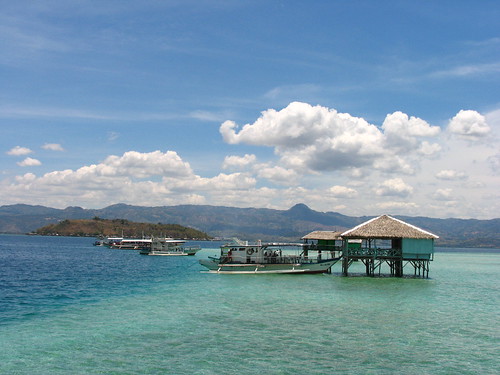

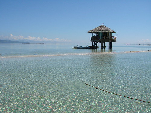
House on stilts
![]() Mabinay Caves, Mabinay
Mabinay Caves, Mabinay

The prevalence of limestone rock and extensive karst phenomena secures Mabinay’s claim to being the Cave Town of Negros Oriental. According to the locals, there are over 400 caves honeycombing Mabinay’s lower regions. In 1989-1990, the Belgian-Dutch-Philippine Club undertook an expedition and identified 45. Among these:
Bulwang – 159 meters long, with icicle-like dripstone. The Provincial Government has installed a walkway into the cave, and amenities at the approach such as a visitors’ reception building and dining hall.
Odloman – at 8,870 meters, went on record as the second longest cave system in the Philippines. Accessed by rappelling through a hole in the ceiling or by swimming 20 meters across an underground river, Odloman has large galleries, many narrow corridors, active streams and more than enough difficult obstacles to lure extreme cavers.
Cayaso – with a subterranean river flowing through its main chamber, measures 2,222 meters long to rank 9th longest cave in the country. Other caves of note:
Baliw – 769 meters long, with white concretions called “white forest.”
Mambajo – 670 meters long (right), has a chimney access and a subterranean river flowing towards a siphon to emerge in Mambajo 2.
Kabugan – 373 meters, with a large opening called the “sunny walk” midway towards a bat-colonized area. (On the other side of the valley is Tokko, a shallow cave only 20 meters deep, believed to be part of the Kabugan system.)
Panligawan and Pandalihan – popular among amateur cavers, comparatively shallow at 143 and 282 meters, respectively. The dome-shaped Panligawan has a skylight, and wide and flat ground ideal for in-cave camping.
Mabinay is an interior highland town 87 kilometers northwest of Dumaguete City, through which a “short cut” highway exits to neighboring Negros Occidental. It is predominantly agricultural, with sugar as the main product. A side-trip to take is Mabinay Spring which feeds a lake set amid lush vegetation in the heart of the poblacion, ideal for picnics and swimming.
Poblacion Mabinay is about an hour and a half north of Dumaguete City by all types of vehicles.
|
|
|
|


![]() White Sand Bar, Manjuyod
White Sand Bar, Manjuyod

A 7-kilometer-long strip of white sand beach in the middle of North Bais Bay. Ideal for swimming and snorkeling. The area is submerged at high tide. Four cottages are available for guests. Manjuyod is 58.2 kilometers from Dumaguete City.
Travel to the White Sand Bar from Dumaguete is approximately 1:5 hours.
Experience the Beauty of Negros: Manjuyod Sand Bar


![]() Mt. Kanlaon, Canlaon City
Mt. Kanlaon, Canlaon City

Mt Kanlaon, the tallest peak in Central Visayas and among the highest in the country, rises 8,050 feet above sea level on the boundary between the two Negros provinces. The crater is approximately 9.5 kilometers from the Canlaon City center. Mt. Kanlaon National Park covers 24,577 hectares, 3,296 hectares or 8% of which are under Negros Oriental jurisdiction. The volcano endows Canlaon City, nestled on its northeastern slopes, with cool weather, fertile soil, and an abundance of natural attractions. The city sprawls at an elevation of 2,600 feet above sea level. It is the take-off point for mountain climbing to the volcano summit, Makawiwili Ridge, and Margaha Valley; or for excursions into a number of waterfalls including Sandugan, Mananawin, Inihawan, Kipot and Sudlon. There are as well unusual sites such as the Masulog Rice Terraces, Bucalan Hot Springs, the OISCA Model Farm, Camp Mapot, and the natural water slides of Padudusan Falls.
Inihawan, also called the “Enchanted Falls,” plunges 100 feet into a verdant setting, approximately 8 kms northeast of the city proper.
Kipot is a bottle-shaped waterfall cascading over rocks to form a wide and deep pond ideal for boating and swimming, about 5 kms from city proper.
Camp Mapot is set on a plateau 5,000 above sea level, on the eastern flank of Mt Kanlaon. Pine trees and hillside springs abound in the area which often serves as jump-off point for mountain climbers essaying the volcano.
At 8,000 feet above sea level Makawiwili Ridge, also known as the “Saddle in the Sky,” straddles two mountain peaks and is frequently used as vantage point for observing the volcano.
The OISCA Model Farm is a 136.4-hectare facility developed by the OISCA (Organization for Industrial, Spiritual and Cultural Advancement) whose Japanese technicians introduced modern mechanized rice culture technology and terraced farming and, subsequently, diversified activities such as citrus and strawberry culture, vermiculture, and fresh-water fishery using water impoundments. The area is characterized by rolling terrain. Other features are a training center, staff houses, tree houses, a coffee plantation, and a reforestation project. Located northeast of Barangay Lumapao, approximately 9 kms from the city proper.
Canlaon City, predominantly agricultural (also referred to as the “rice and vegetable bowl” of the Province) has three public markets.
Canlaon City is 167.21 kms north of Dumaguete City, or approximately 4 hours travel time.
The Sugar Plantations with the Mount Kanlaon in Negros Island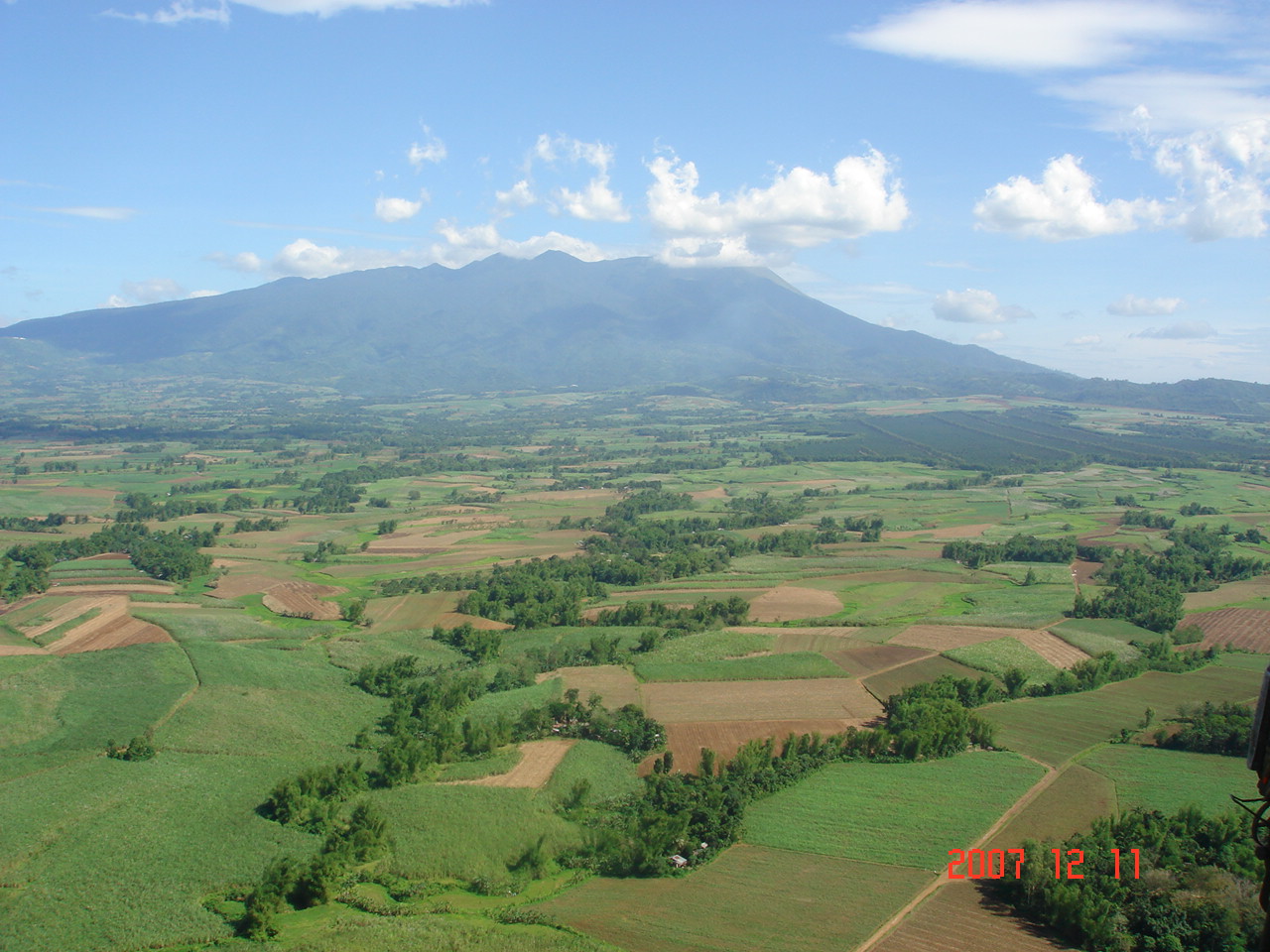

The Twin Lakes:
Balinsasayao and Danao, Sibulan

The Twin Lakes Natural Park is approximately 8,000 hectares, part of the 133,000-hectare Geothermal Reserve managed by the PNOC. The main features are Lakes Balinsasayao and Danao, contained in adjacent calderas 1,000 meters above sea level and separated by a ridge 20 meters in width. The lakes are completely surrounded by forest and lush vegetation of about 3,462 hectares spread over the Guintabon, Kabalin-an and Guinsayawan mountain ranges which serve as protection dikes to the lakes. The bigger lake Balinsasayao has a surface area of 76.25 hectares, Danao 30 hectares. Depth is approximately 80 meters, with Danao’s water level 10.04 inches higher. Volume of water in both lakes is estimated at 77,600 cubic meters, with no visible outlet. Seepage feeds the geothermal reserves tapped by PNOC. About a kilometer below the access slope to the Twin Lakes is Kabalin-an Pond, a shallow body of fresh water about 2.4 hectares, beside which the Provincial Government has built a visitor’s reception center and parking lot. The banks of Kabalin-an provide refreshing picnic spaces. Discovery of the area is attributed to Don Miguel Patero in 1885. The American missionaries Mr. Bell and Dr. Carson, who had evacuated to the Twin Lakes, called a meeting in the area to unite the guerilla forces during WWII. The
The Twin Lakes are approximately 1 hour by 4-wheel drive or motorbike from Dumaguete City.
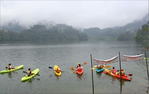
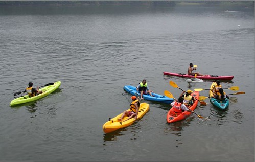
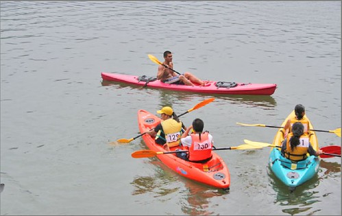
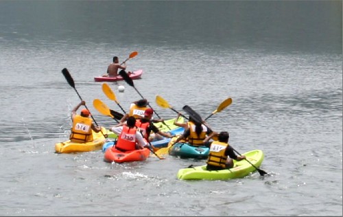
Kayaking at Lake BalinsasayawSibulan, Negros Oriental
![]() Apo Island, Dauin
Apo Island, Dauin

A 72-hectare, 200-meter high volcanic island about 5 kilometers off the municipality of Dauin. Five pocket beaches of white pebbles, two mangrove lagoons, and a lighthouse. The Apo Island Protected Landscape and Seascape comprises 691.45 hectares (72 terrestrial, the remaining is the marine area surrounding the island). An average total coral cover of 63.1% and a magnificent variety of corals and marine life led to Apo Island’s being acclaimed as one of the world’s Ten Best Divesites. Coconut Point is referred to as the best divesite in southern Visayas. In “Clown-fish City” the colorful Amphiprion melanopus inhabit anemones that have colonized seven large coral heads. This underwater splendor is replicated in the Schedd Aquarium of Chicago. Apo Island is approximately 45 minutes by motorized outrigger (pumpboat) from Dauin.

There is a church, an elementary school and several sari sari stores for basic needs. There is no nighlife to speak off , I like it that way, no blaring karaoke machines singing "My Way" on the middle of the night.
Water is scarce, and expensive too, all drinking water are still coming from the mainland. The people are very friendly, and can speak conversational English, probably because of the foreign divers that frequent visit the place.
I truly admire the friendliness of the people of Apo and their willingness to help, people know as well when you arrive and what resort you are staying, hmm... that really shows how small the island is, local knows all new guests . The vendors are all interested to know when are you going home... why? for them to sell their "only in Apo" tshirt.
Apo Island Marine Reserve PHILIPPINES

Apo Island Beach Resort

One was Apo Island, a small island of only 1000 people. There is no power there except for a generator that runs from 6pm to 11pm every day. The marine sanctuary there had amazing snorkeling.
Balanan, Sandulot, Siaton

 An expansive mountain resort developed around Balanan Lake, a humerus-shaped body of water, 25 hectares in surface area, 285 ms above sea level, oriented along a northwest-southeast direction (right). The lake encases a kilometer-long waterway ideal for water sports. Among the prominent features of the resort is a 4-kilometer circumferential pathway for trekking, a variety of pools for swimming, passenger bancas for boating, waterfalls for great photo-ops. Balanan has an old forest of almost a hundred balete trees, atop one of which is a treehouse. An 8-room hillside hotel, Balodge (left) provides air-conditioned comforts with a view of the lake. Other amenities include a thatched dining pavilion and a staffhouse. Balanan Lake Development Authority will implement regular rates beginning May 19. Entrance is free every Tuesday.
Balanan is 60 kilometers from Dumaguete City, or approximately 1:5 hours travel time.
Pictures of Balanan Lake Siaton

 view from the main cottage
 Swimming pool of Balanan
 One of the three spring-fed swimming pools at the Balanan Lake
Balanan Jeepney or Balaney